
Kilauea Eruption: No Lava for Two Months
Volcanic activity at Kilauea Volcano which was extremely active from May to August of this year gradually shut down in early August and has been dormant ever since. Residents of the area are contemplating what’s next with the county and state government trying to decide what to do in so far as infrastructure goes. Some road repairs have been made in Leilani Estates, one of the areas hardest hit by numerous lava flows. Several residents have continued to blog on social media sites such as YouTube and Facebook regarding the latest status of the volcano.
The Hawaii Volcanoes National Park re-opened in late September after closing due to earthquake and explosive hazards surrounding the activity at Kilauea Caldera. The U.S. Geological Survey continues to monitor the Kilauea’s summit and lower east rift zone for any signs of activity. Here are their latest reports:
HAWAIIAN VOLCANO OBSERVATORY WEEKLY UPDATE
U.S. Geological Survey
Tuesday, October 23, 2018, 6:40 PM HST (Wednesday, October 24, 2018, 04:40 UTC)
KILAUEA VOLCANO (VNUM #332010)
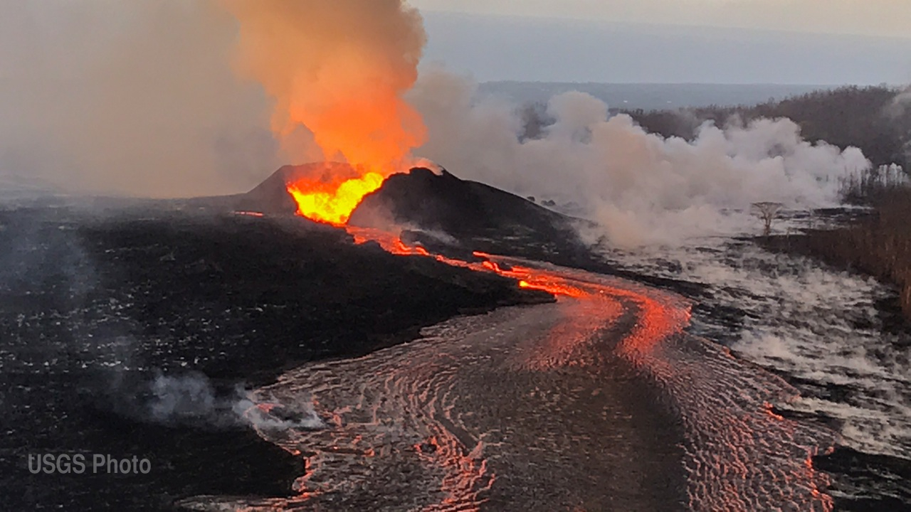
19°25’16” N 155°17’13” W, Summit Elevation 4091 ft (1247 m)
Current Volcano Alert Level: ADVISORY
Current Aviation Color Code: YELLOW
Activity Summary: Kīlauea Volcano is not erupting. Rates of seismicity, deformation, and gas release have not changed significantly over the past week. Deformation signals are consistent with refilling of the middle East Rift Zone.
Observations: HVO monitoring during the past week shows low rates of seismicity at the summit and East Rift Zone (ERZ). Earthquakes continue to occur primarily at Kīlauea’s summit area and south flank (magnitude-3.8 was the largest) with continued small aftershocks of the magnitude-6.9 quake on May 4, 2018. Seismicity remains low in the lower ERZ.
In the ERZ, tiltmeters near Puʻu ʻŌʻō and farther east continue to record an inflationary trend, consistent with refilling of the middle East Rift Zone. At the summit, tiltmeters have recorded a slight inflationary trend. At the summit, UWE tiltmeter started a deflationary trend around 2018-10-18 18:30, and seems to have completed a DI cycle over 3-4 days since.
Sulfur dioxide gas emissions at the summit, Puʻu ʻŌʻō, and the ERZ remain drastically reduced. The most recent SO2 emission measurements, from late September, show a combined rate of less than 300 tonnes/day. Bad weather has prevented new SO2 emission rate measurements; however, downwind SO2 concentrations suggest that no major changes have occurred over the last week.
Hazards are still present in the lower East Rift Zone (LERZ) eruption area and at the Kīlauea summit. Residents and visitors near recently active fissures and lava flows should stay informed, heed Hawaii County Civil Defense and National Park warnings, and be prepared, if necessary, to self-evacuate in the unlikely event of renewed activity. Please note that Hawaii County maintains a closure of the entire flow field and the vents and prohibits access to the area unless authorized through Civil Defense.
The Hawaiian Volcano Observatory (HVO) continues to closely monitor Kīlauea’s seismicity, deformation, and gas emissions for any sign of reactivation, and maintains visual surveillance of the summit and the East Rift Zone. HVO will continue to issue a weekly update (every Tuesday) and additional messages as warranted by changing activity.
MORE INFORMATION
Activity summary also available by phone: (808) 967-8862
Subscribe to these messages: https://volcanoes.usgs.gov/vns2/
SUMMARY OF 2018 KILAUEA VOLCANO ERUPTION (from the USGS PDF)