Behold Hurricane Olivia
It is quite annoying to be bothered by hurricanes and tropical storms. Alas, it is hurricane season and this year it seems to be picking up with more storms coming near Hawaii and actually threatening us with high winds and plenty of rain.
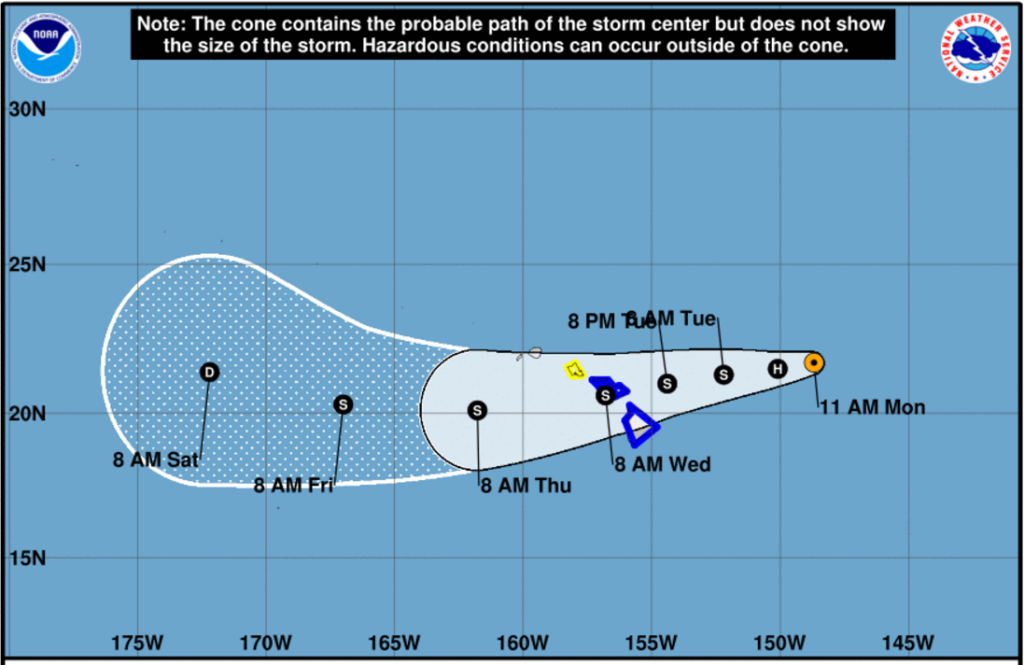
The latest is Olivia which is several hundreds of miles to the east of the state and moving in a westerly direction. A tropical storm watch is up for Oahu and a tropical storm warning is up for Maui and Hawaii counties. There is a possibility that all of these alerts will be increased to hurricane warnings as this storm moves closer. So far it is a CATEGORY 1 hurricane with winds clocked in a 85mph.
It is certainly not as threatening as Hurricane Lane that moved in to the state in August before turning north and fizzling out.
Behind Olivia there is Tropical Storm Paul, churning several thousand miles away in the Eastern Pacific but moving westward.
Attached below will be the latest updates from the NOAA regarding Olivia. This post will be periodically updated.
BULLETIN
Hurricane Olivia Advisory Number  41
NWS Central Pacific Hurricane Center Honolulu HI   EP172018
1100 AM HST Mon Sep 10 2018

...AIR FORCE RESERVE HURRICANE HUNTERS FIND OLIVIA IS STILL A
HURRICANE TO THE EAST OF HAWAII...


SUMMARY OF 1100 AM HST...2100 UTC...INFORMATION
-----------------------------------------------
LOCATION...21.7N 148.7W
ABOUT 435 MI...700 KM ENE OF HILO HAWAII
ABOUT 590 MI...950 KM E OF HONOLULU HAWAII
MAXIMUM SUSTAINED WINDS...75 MPH...120 KM/H
PRESENT MOVEMENT...W OR 270 DEGREES AT 9 MPH...15 KM/H
MINIMUM CENTRAL PRESSURE...986 MB...29.12 INCHES


WATCHES AND WARNINGS
--------------------
CHANGES WITH THIS ADVISORY:

None.

SUMMARY OF WATCHES AND WARNINGS IN EFFECT:

A Tropical Storm Warning is in effect for...
* Maui County...including the islands of Maui, Molokai, Lanai, and
Kahoolawe
* Hawaii County

A Tropical Storm Watch is in effect for...
* Oahu

A Tropical Storm Warning means that tropical storm conditions are
expected somewhere in the warning area within 36 hours.

A Tropical Storm Watch means that tropical storm conditions are
possible in the watch area within 48 hours.

Interests on Kauai and Niihau should closely monitor the progress
of Olivia.

For storm information specific to your area, please monitor
products issued by the National Weather Service office in
Honolulu Hawaii.


DISCUSSION AND OUTLOOK
----------------------
At 1100 AM HST (2100 UTC), the center of Hurricane Olivia was
located near latitude 21.7 North, longitude 148.7 West. Olivia is
moving toward the west near 9 mph (15 km/h). A continued west to
west-southwest motion is expected for the next few days. On the
forecast track, the center of Olivia will be moving over the main
Hawaiian Islands Tuesday night into Wednesday.

Air Force Reserve Hurricane Hunters recently found that
Olivia is still a hurricane, with maximum sustained winds near
75 mph (120 km/h), with higher gusts. Little change in intensity is
expected today, with gradual weakening expected afterward. Olivia
is expected to approach the islands as a strong tropical storm.

Hurricane-force winds extend outward up to 15 miles (30 km) from the
center and tropical-storm-force winds extend outward up to 105 miles
(165 km).

The estimated minimum central pressure is 986 mb (29.12 inches).


HAZARDS AFFECTING LAND
----------------------
WIND: Tropical storm conditions are expected somewhere within the
warning area starting late Tuesday. Tropical storm conditions are
possible within the watch area starting late Tuesday night or early
Wednesday morning.

RAINFALL: Olivia is expected to produce total rainfall accumulations
of 10 to 15 inches. Isolated maximum amounts of 20 inches are
possible, especially over windward sections of Maui County and the
Big Island. This rainfall may produce life-threatening flash
flooding.

SURF: Large swells generated by Olivia will spread from east to
west across the Hawaiian Islands early this week. This will cause
surf to build along exposed east facing shorelines as Olivia
approaches. This surf may become damaging across parts of the state.

